

The summit of Red Hill was the meeting point of three 1840s Mexican land grants: Rancho Canada de Herrera, Rancho Punta de Quintin, Corte de Madera, la Laguna y Canada, and Rancho Las Gallinas Punta de San Pedro y Santa Margarita. On early maps, Red Hill is called Sugar Loaf. Red Hill is 464 feet high. It is pillow basalt rock formed from submarine volcanic activity. Exposed pillow basalt weathers in time to red causing the red soil.
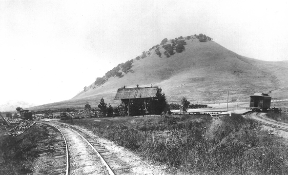
Red Hill rises above the lonely outpost known as the Junction. Pictured here and taken circa 1875 is the first depot at the hub of what would become San Anselmo. Pictured are the tracks to Fairfax and points west and the tracks to San Rafael.
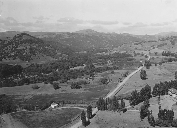
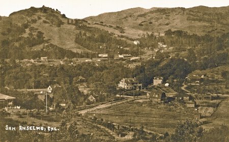
Panoramic View From Red Hill Towards Fairfax.
In the lower left corner is the Biggio/Canepa House and the Carrigan House is left of center middle. Further along the road is the Cordone vegetable garden and the Chiappari farm. Just off the lower right edge of the photo is the Presbyterian Orphanage building (Sunny Hills).
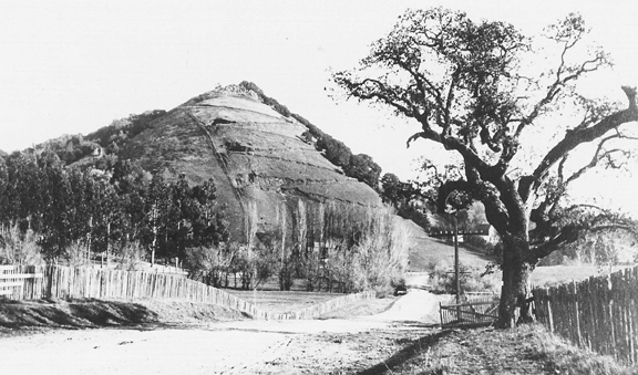
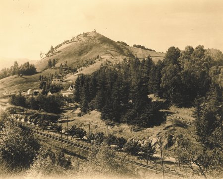
Red Hill from Tamal Avenue.
The zigzag road on the western slope was constructed around 1893 by Dr. Henry DuBois who owned a portion of Red Hill and the Mt. Tamalpais Cemetery on the other side. Dr. DuBois hired Chinese laborers to build a road over the hill to provide access to the cemetery. The road was too steep for a horse and buggy to make it to the top and to the cemetery. The jagged road was later dubbed “DuBois’ Folly” and is still clearly visible on the upper portion of the hill.
In 1916, an auto made it to the top of Red Hill!
San Anselmo Herald
Friday, June 16, 1916Take Auto Ride to the Top of Red Hill
Lil Minstrel and Donald Eastman made an auto trip Sunday to the top of Red Hill, going up in Lil’s Ford, and from reports they had some time. It was not so much the length of the trip or the steepness of the incline but the numerous short turns in winding back and forth across the face of the hill, and the fact that it was the first vehicle to go to the top of the hill in twenty-three years, and the second one that was ever taken to the top that made it a novelty trip. They had taken a mattock along and had to dig out in places so they could make some of the turns. The speedometer showed that it was three quarters of a mile up the hill, but it took them an hour and a quarter to make the trip up.
Mr. McGetta, who lives at the foot of the hill, went up with them. He has lived there 32 years and says he was the only man who had ever taken a vehicle up the hill previous to that time. He went up once and brought down a wagonload of wood, but the road was too dangerous to try it again.
The report has started that several others have said they would make the trip in their cars, but unless the cars are coupled up pretty short it will be impossible for them to make all the turns, and might result disastrously. At any rate we don’t believe we should venture to take such a ride unless we had a pretty good amount of accident and life insurance.
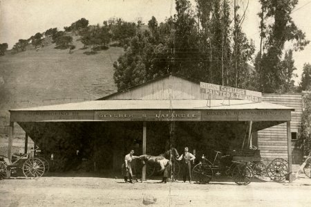
Deysher & Lafargue
The road from San Rafael to Fairfax passes under the foot of Red Hill. The small strip of land between the road and the steep slope of the hill provided a perfect place for roadside businesses. An early occupant was Cochrane’s Blacksmith Shop, which was taken over by William Deysher. Deysher took Ben LaFargue as a partner in early 1908. They later expanded into a plant manufacturing rail cars and fire engines.
Rose Shapira opened the area’s first drugstore next door, moving across the street in 1913.
This part of town was the first place to get gasoline during the 1930s. There was a choice between Shell, Gilmore, Texaco or Richfield.
View of San Anselmo from Crescent Road
This view of Red Hill was taken in 1911 from above Crescent Road. The Robson-Harringrton House, owned by E.K. Wood at the time, is in the center.
Red Hill from the East
The northern portion of the hill lies within the land grant awarded to Timoteo Murphy, Las Gallinas Punta de San Pedro y Santa Margarita. The fence running down the slope divides it from the land grant Punta de Quintin, Corte de Madera, la Laguna y Canada. The Ancha Vista Hotel is in the left center partially hidden by trees. In 1915 the California State Mining Bureau listed a mineral spring on the slope of Red Hill, in sandstone at an elevation of 150′. The spring had been known for over 30 years but utilized medically only a few years prior to the state report. Analysis by the University of California showed 21 grains per gallon, principally magnesia and lithia. The Ancha Vista Hotel and cottages were located on adjoining property.
The house beyond the hotel stands today on Essex Street. In the foreground is the railroad track between San Rafael and San Anselmo with a row of trees separating it from the San Rafael-Olema Road (Red Hill Avenue).
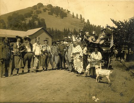
Clowns waiting for the parade to start
Red Hill stands in the background in the above photograph. They called them “The Horribles” – costumed clowns, bumpkins and what have you – who added a touch of merriment to the San Anselmo 4th celebration in 1909.
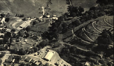
Aerial View of Sunny Hills School and Farm
This aerial photo was taken in the late 1950s. The Sunny Hills Orphanage main building is in the upper left. The Orphanage had a working farm on land that is now Red Hill Shopping Center from 1920 to 1963. Red Hill rises on the right, the switchback road clearly visible.
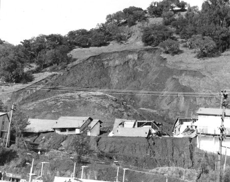
Slide and breakoff of Red Hill
A non-stop storm inundated Marin County with over 15 inches of rain on Friday and Saturday, January 20-21, 1967. The most spectacular damage was on Red Hill in San Anselmo where four of five 2-story apartment buildings were collapsed and shoved 60 feet under tons of mud. Town officials were reluctant to grant building permits for the apartments the year before but yielded to assurances that soil tests had been satisfactory.